Deciphering territorial claims and reasons behind exclusion of few districts
If William Shakespeare were alive today, China would have questioned his “What is in a name?” line from ‘Romeo and Juliet’ and defended its renaming efforts (of locations) countering that ‘naming of things is relevant’.
The renaming spree in Arunachal Pradesh (names in standardised Chinese, Tibetan and Pinyin characters with latitude and longitude and a high resolution map) was started in 2017 and has spatial and temporal history including in Tibet, Xinjiang, South China Sea (SCS) and East China Sea (ECS). For example, People’s Republic of China (PRC) has Chinese names for all the islands of Spratly Islands Group (the Nansha Islands) and Paracel Islands (Xisha islands).
The renaming covered a total of 62 locations including villages and towns (25), mountain peaks and passes (25), land segment (3), and rivers, streams, and lakes (9) with six locations in first batch (April, 2017), fifteen in 2nd batch (December, 2021), followed by eleven in April, 2023 and thirty in March, 2024.
Wu Qian, spokesman of Defence Ministry of China had rejected (March, 2024) India’s right to Arunachal Pradesh by saying : “It is an undeniable fact that Zangnan has been Chinese territory since ancient times, where does the so-called ‘Arunachal Pradesh’ come from?”.
This statement justifies the fact that it took China almost seven years for renaming and official publication of 62 Indian locations. This long, staggered duration adopted by China is possibly due to efforts by Chinese scholars (at the directions of People’s Republic of China) to bake data to attach historical and cultural ties of renamed locations with Tibet and other parts of China, which can then be used to satisfy and justify, if need arises, the audience both domestic and global.
China does not claim whole of the state of Arunachal Pradesh, at least if one goes by the 2023 edition of China’s Standard Map of Standard Map Service of the Ministry of Natural Resources, PRC.
Arunachal Pradesh currently has 26 districts and however districts like East Kameng, Kamle, Leparada, Lohit, Siang, Changlang, Tirap, Longding, and Namsai did not feature any of the renamed locations. East Kameng, Kamle, Leparada, Lohit, and Siang districts fall within the boundary of China’s claimed territory formed by 62 renamed locations. If one carefully looks at the China’s Standard Map of 2023 and Chinese version of Google Earth map, China’s claims on Arunachal Pradesh exclude the whole of the districts of Changlang, Tirap, Longding, Namsai and most of Lohit district and parts of Anjaw district.
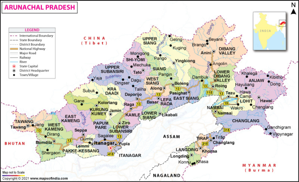
As per the 2011 Census Data of India, there were 5587 villages in Arunachal Pradesh. If we remove 845 villages (115 of Lohit district, 178 of Namsai district and 362 of Changlang and 190 villages of Tirap district & Longding district), theoretically China claims over 4735 villages.
But there is a notable discrepancy in China’s claims over Arunachal Pradesh. According to sources including the Chinese, the so called South Tibet (Zangnan) encompasses an area of approximately 90,000 to 93,000 square kilometre and is said to have a population of approximately one million. When Arunachal Pradesh is only 83,743 square kilometre as per Government of India, where is the additional 6000-9000 square kilometre of territory in the so called Zangnan.
Also, 2023 edition of China’s Standard Map excludes 13,816 square kilometre area comprising Changlang, Tirap, Longding, Namsai and most of Lohit district and parts of Anjaw district. Therefore, China needs to tell the world where is this additional claim of 19,816-22,816 square kilometre area of the so called Zangnan (13,816 square kilometre combined with 6000-9000 square kilometre).
It could be possible that Zangnan has parts of it in Bhutan and or Myanmar and China does not want to admit this in public to avoid diplomatic collision or there is something seriously wrong with Survey of India’s measurement of the Arunachal Pradesh or PRC is confusing the stakeholders as its claims are baseless and unsubstantiated. Looking at the China’s history of territorial claims, the latter is the most plausible explanation. It appears that China is following Sun Tzu’s quote “the whole secret lies in confusing the enemy, so that he cannot fathom our real intent” in letter and spirit.
China kept these districts of Arunachal Pradesh out of the Standard Map 2023 due to following reasons: districts of Changlang, Tirap, Longding have strong presence of National Socialist Council of Nagalim- Yung Aung (NSCN-YA), United National Liberation Front of Asom- Independent (ULFA-I), and National Socialist Council of Nagalim-Isaac/Muivah (NSCN-IM) who reportedly received China’s support (financial, training, weapons) and are three of the many North East India origin Insurgent Groups with various demands including a separate nation state and more autonomy. These IIGs do operate under the China’s umbrella of influence and act as its eyes and ears. So by not including these districts, China has kept them on its side. Another reason is China would be avoiding administrative and strategic inconvenience of not getting surrounded by India and Myanmar in districts of Changlang, Tirap, Longding, Namsai, Lohit and parts of Anjaw in which case it will be China’s chicken’s neck.
By renaming locations in Arunachal Pradesh what China (from its strategic perspective) has done is delimitation of Arunachal Pradesh which (delimitation) is usually the first step in any sacred bilateral relations for establishment of boundary and or resolution of any boundary issue. The other two steps being delineation and demarcation (usually in that order). Through delimitation one intends to identify the dots (may be residential areas, mountains and passes, rivers etc) in a particular area in order to conceptualise the boundaries or limits which in turn gives a sense of where the boundary of the area in question begins and ends.
Plotting latitudes and longitudes of all the 62 Indian locations renamed by China since 2017, gives a sense of geographical area covered (where the boundary begins and ends) which can later be delineated and demarcated by drawing lines on a map and construction of boundary pillars respectively. It covers almost all the districts except for the whole of the districts of Changlang, Tirap, Longding, Namsai and most of Lohit district and parts of Anjaw district which do not form part of Chinese claimed Indian territory of Arunachal Pradesh as can be seen in China’s Standard Map, 2023.
A critical analysis events surrounding Cha’s actions in Arunachal Pradesh reveals that some of the 62 renamed locations have earlier been transgressed by Chinese PLA wherein they had set up their tent and stayed for a few hours including hiring of Indian porters as happened in October, 2018 during which Chinese troops had entered approximately 14 kilometre inside near the banks of Mathu and Emra Rivers in Dibang valley. Emra River is a right-bank tributary of the Dibang River located in Dibang Valley district which eventually flows into the Brahmaputra River. Emra River (with the Chinese Pinyin name Niangmuri He) was in the fourth list of renamed locations released by China in March, 2024. The recent example of PLA spray painting rocks in Kapapu, near Chaglagam of Anjaw District is a testimony.
China needs reason/s to sustain its aggression especially in disputed territories. In case of Taiwan, it is that (China’s claim) it is one of the last remaining symbols of China’s reported history of centuries of humiliation and for SCS, it is the imaginary nine dash line. The renaming attempts in hitherto undisputed Arunachal Pradesh are because China needs to convince its domestic audience, allies and if necessitated the international jury with reasons for its claims before making any strategic decisions to carry on with its aggression tactics along the McMahon line and attempts to (if) occupy.
According to American Mandarin Society, China’s PLA has India specific military doctrine called “Border Self-Defense Counterattack Operations” detailed in Science of Military Strategy, 2013 Edition of Academy of Military Science’s Military Strategy Research Department, Beijing. From China’s point of view, this is a euphemism for “joint” PLA operations to fight along the China-India border with the objective to capture disputed territory (allegedly currently controlled by India) in order to improve China’s “defensive” position; thereby resolutely “protecting territorial sovereignty and restoring border area peace and stability.”
By renaming locations and giving baked history of their association with China, the latter is building a narrative to its domestic and global audience (as it is answerable to them, at least in theory!) that India is the aggressor here allegedly occupying its territory and China is only legitimately trying to reclaim them (in case it launches such operations). Therefore renaming locations and associating them with China is the first step before it can pursue its India specific military doctrine called “Border Self-Defense Counterattack Operations” .
Should China make attempts to occupy Arunachal Pradesh is best left to the wisdom of leaders of CCP and PRC as most countries including China and global institutions understand the reality that India, as a rising power, of 21st century is different and has moved on from 1962. China also understands that any such cross border attempts will be nothing but a mutually assured destruction of both nuclear powers. However, it is a totally different subject matter which will be explored in an another article another day.
Map aggression is one of the tactics of China that are intentionally ambiguous to create confusion among the stakeholders as it does in SCS without any concrete progress in ‘Declaration on the Conduct of the Parties’ and ‘Framework for a Code of Conduct in the SCS’. It is much easier for any aggressor like China to continue with its geopolitical game of keeping the claimants guessing particularly in boundary disputes as it gives much larger space to manoeuvre the stakeholders.
Similarly in Arunachal Pradesh, China is keeping policy makers in India guessing and confused. India should tread this China’s design with utmost planning and counter China’s efforts by augmenting its current policy of enhancing border civilian and military infrastructure along the McMahon line. In addition, coordinated efforts be made along with other stakeholders in SCS and ECS to expose China’s falsified claims and records in order to send a united message to China’s domestic and global audience that China cannot succeed in its ill designs to capture territories of other sovereign nations.